Kerman
Kerman Province is situated in southeast Iran, to the southwest of the Kavir-e Lut, Lut Desert or Dasht-e-Lut) covering an area of 182,000 km² (70,000 square miles). Kerman is the largest province in Iran, constituting 11 percent of its soil. The province lies between lat 26°29′ and 31°58′ N and long 54°20′ and 59°34′ E; it forms roughly an inverted right triangle facing west, with an east-west base of 470 km in the north and height of 630 km. The province is bounded in the southwest by Hormozgan and Fars Provinces, in the northwest and north by Yazd Province, in the northeast by Khorasan Province, and in the east by Sistan and Baluchistan Province.
The highest mountains in Kerman are the summit Jupar (4,089 m) overlooking the city of Kerman, Lalazar (4,234 m), Hazar (4,465 m) near Rayen, and Bahr Aseman (3,046 m). It is in the foothills of these mountain chains that the upland oases of the province lie.
The province falls into the arid and semi-arid zones and like much of the Iranian plateau suffers from scarcity of water—a dire condition as the population continues to grow. There are several, but mostly seasonal, mountain streams. The only significant river is the Halilrud, about 400 km long. It irrigates the vast fertile plain of Jiroft and disappears further south into the marshes of the Jaz Murian. The average annual rainfall is low and decreases towards the southeast, although the topography gives rise to many local variations. Maximum precipitation occurs in winter; the annual average rainfall is 80 mm and 142 mm in the cities of Bam and Kerman respectively. But precipitation is more abundant at higher elevations, and the snow that falls in the mountains refills the aquifers from which manmade underground channels (qanat, kariz) draw water for irrigation, notwithstanding the brackishness of the qanats’ outflow in many places. Most of the older subterranean watercourses have dried up, whether because the flow in the aquifers is entirely consumed or the underground water is sucked out by electric pumps; since the 1940s, the use of deep wells has become prevalent for creating islets of intensive cultivation.
The binary climatic division of the Iranian Plateau into cold and warm zones (sardsir and garmsir) is quintessential in Kerman. The province is divided into two distinct macroclimates, sardsir in the upland north and garmsir in the lowland south, generally speaking. The upland Sirjan has a temperate climate, while Kerman, Rafsanjan, Zarand, and Ravar have hot summers and mild winters. The southern districts of Bam, Jiroft, Kahnuj, and Manujan are characterized by having warm climate with an increasing humidity towards the Sea of Oman and the Indian Ocean. At the city of Kerman, with an elevation of 1,762 m, the average high temperature in January is 11.8° C, and the average low is -4.0° C. In July the average maximum and minimum are 35.5° C and 17° C, respectively. Put in a national perspective, with consideration of temperature and precipitation combined, the district of Kerman lies within a “steppe” climate, compared with the desert status of Yazd and Zahedan and the humid status of Bandar ʿAbbas.

Despite the favorable condition the mountains provide for human settlement, they are also the cause of destructive earthquakes. Modern documentation reveals an average return period of five to ten years for significant seismic events. The highest seismic activity belongs to the fault system called Gowk along the longitudinal edge separating the Kerman plateau from Dasht-e Lut. It extends some 100 km approximately from Shahdad to Golbaf. A shorter fault in the south, also running longitudinally, was responsible for the devastating Bam earthquake in December 2003.
Administrative boundaries and divisions. Although the geographical concept of Kerman in its narrow sense pertains chiefly to the cold highlands or the northern plateau that covers the current province, in a wider sense, at least in modern history, Kerman was one of the four eyalats or super-provinces (together with Azerbaijan, Khorasan, and Fars) that formed four quadrants over the map of Persia, an arrangement perpetuated by the law of territorial divisions of 1907. In this setting, Kerman Province, also known as Kerman and Makran or Kerman and Baluchistan, extended eastward up to the Indo-Persian border and southward to the Sea of Oman. The administrative reforms of 1934-38, which divided Persia into ten provinces, made little change in the borders of the former Kerman province, which was now called the Eighth Province (constituting Kerman, Bam, Bandar ʿAbbas, Ḵhash, and Zabol. The territory of the Eighth Province shrank over the subsequent decades, to what is now called Kerman Province, due to two major secessions. The eastern half of the historical province was incorporated into the new province of Sistan and Baluchistan, and the southern coast was carved off to form what is known today as the province of Hormozgan.
In spite of all these variations, the city of Kerman (1,038 km distance to Tehran) remains the most important provincial capital in the southeastern quarter of Iran.

Economy. Having economically ranked low among Iranian provinces and cities for most of the 20th century, Kerman became engaged in national economy through exploitation of its rich mines, expansion of transportation infrastructure, and establishment of educational and tourism services.
Agriculture still plays an important role in the economy of Kerman Province. The upland regions have diversified subsistence farming of cereals, potatoes, cotton, sugar beets, oilseeds, vegetables, and a large variety of fruits, including peaches, cherries, apples, pears, persimmons, as well as nuts. Kermani cumin, mostly cultivated in Baft, enjoys such a nationwide reputation that it has led to the proverb: zira beh Kerman bordan (lit. “carrying cumin to Kerman”), approximating the English phrase of “carrying coals to Newcastle.” Pistachios, another famous product of the province that is farmed in Rafsanjan, has in recent decades become subject to semi-mechanized agronomy and is produced in such a large quantity that it is exported abroad after saturating national markets. Production of another labor-intensive crop, sugarcane, is rapidly expanding, especially in Bardsir (Razavi). In the warm lowlands of the province, rice, cereals, fruits, and henna are grown. The agriculture of Bam has come to be dominated by date palm and citrus farming, the produce of which is marketed throughout Iran.
Animal husbandry has lost its edge in the province. Tending large flocks of sheep and goat was partly an occupation of various nomadic groups throughout the province including the Afshars who wintered in Jiroft and summered in Baft. They produced wool, including down wool (kork), which was used in weaving the famous shawls of Kerman. Erosion of the traditional nomadic and rural base and destruction of the grassland through overgrazing has resulted in a sharp decline in animal herding.

Kerman has long excelled in manufacturing textile and weaving carpets. The Kerman carpet is as famous as its cumin and is the subject of a Persian metaphor meṯl-e qāli-e Kermān (“like a Kerman carpet”), implying the idiomatic expression “the older, the better.” Carpet manufacture remains one of the main industries of Kerman city and its neighboring districts, although its international market is far less promising than it used to be. There were also many textile factories that produced Kerman’s famous shawls, brocade (terma;), and ʿabāʾ, but these are no longer flourishing, while patta-duzi, an embroidering art still survives as a cottage industry.
No business engages Kerman with the national networks to a greater extent than mining does. Extensive mining of coal, iron ore, and copper is being carried on in various parts of the province. Coal deposits extend in the mountains from Zarand to Ravar, yielding most of national coal consumption in Iran. The iron ore deposits of Gol Gowhar in Sirjan sub-province are one of largest worldwide. Copper deposits of Kerman Province extend along a beltline from Shar-e-Babak southeastwardly. The richest copper mine, one of the largest in the world, is at Sarcheshmeh, located 50 km south of the city of Rafsanjan. Systematic mining operations were begun in 1972 by the Sarčašma Copper Company, operated since 1976 under the auspices of the National Iranian Copper Industries Co.
Modern transportation infrastructure has been the most essential means in bringing Kerman out of its historical isolation caused by deserts and mountains. In addition to the grid of modern highways that connect urban centers within and without the province, the Tehran -Kerman line of the trans-Iranian railway extends as far south as the city of Kerman and reaches Zahedan. Another railway branch from Yazd, to Bafq and Bandar Abbas, bypasses Kerman City but cuts across the western parts of the province to reach the copper mines of Sarcheshmeh and iron ore mines of Gol Gowhar. The railroad also gave rise to the idea of a Sirjan Free Trade Zone, designed to become a nodal point on a commercial transit grid between the southern seaport terminals and the inner plateau. Last but not least is air transport, in which Kermani businessmen made a surprising initiative in 1992 by establishing Mahan Airline, which has grown to one of the largest airline companies in the country.
Qanats
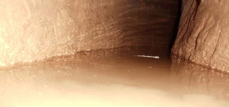
Throughout the arid regions of Iran, agricultural and permanent settlements are supported by the ancient qanat system of tapping alluvial aquifers at the heads of valleys and conducting the water along underground tunnels by gravity, often over many kilometres. The eleven qanats representing this system include rest areas for workers, water reservoirs and watermills. The traditional communal management system still in place allows equitable and sustainable water sharing and distribution. The qanats provide exceptional testimony to cultural traditions and civilizations in desert areas with an arid climate.
Persian Gardens
The Persian Garden consists of a collection of gardens, selected from various regions of Iran, which tangibly represent the diverse forms that this type of designed garden has assumed over the centuries and in different climatic conditions.
They reflect the flexibility of the Chahar Bagh, or originating principle, of the Persian Garden, which has persisted unchanged over more than two millennia since its first mature expression was found in the garden of Cyrus the Great’s Palatial complex, in Pasargadae. Natural elements combine with manmade components in the Persian Garden to create a unique artistic achievement that reflects the ideals of art, philosophical, symbolic and religious concepts. The Persian Garden materialises the concept of Eden or Paradise on Earth.
The perfect design of the Persian Garden, along with its ability to respond to extreme climatic conditions, is the original result of an inspired and intelligent application of different fields of knowledge, i.e. technology, water management and engineering, architecture, botany and agriculture. The notion of the Persian Garden permeates Iranian life and its artistic expressions: references to the garden may be found in literature, poetry, music, calligraphy and carpet design. These, in turn, have inspired also the arrangement of the gardens. The attributes that carry Outstanding Universal Value are the layout of the garden expressed by the specific adaptation of the Chahar Bagh within each component and articulated in the kharts or plant/flower beds; the water supply, management and circulation systems from the source to the garden, including all technological and decorative elements that permit the use of water for functional and aesthetic exigencies; the arrangement of trees and plants within the garden that contribute to its characterization and specific micro-climate; the architectural components, including the buildings but not limited to these, that integrate the use of the terrain and vegetation to create unique manmade environments; the association with other forms of art that, in a mutual interchange, have been influenced by the Persian Garden and have, in turn, contributed to certain visual features and sound effects in the gardens.

The Persian Garden represents a masterpiece of human creative genius. The design of the Persian Garden, based on the right angle and geometrical proportions, is often divided into four sections known as Chahar Bagh (Four Gardens). The creation of the Persian Garden was made possible due to intelligent and innovative engineering solutions and a sophisticated water-management system, as well as the appropriate choice of flora and its location in the garden layout. Indeed, the Persian Garden has been associated with the idea of earthly Paradise, forming a stark contrast to its desert setting.
It is the geometry and symmetry of the architecture, together with the complex water management system, that seem to have influenced design in all these gardens. The word Paradise entered European languages from the Persian root word “Pardis”, which was the name of a beautiful garden enclosed behind walls.
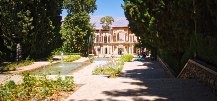
Shazdeh Garden
meaning Prince’s Garden is a historical Persian garden located near (6km away from) Mahan in Kerman province, Iran. Mahan is a city in and capital of Mahan District, in Kerman County, Kerman Province, Iran.
Mahan is well-known for the tomb of the great Sufi leader Shah Ne’emat Ollah-e-Vali, as well as Shazdeh Garden (Prince’s Garden).
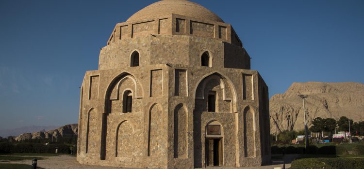
The tomb of Shah Nur-eddin Nematollah Vali, poet, sage, Sufi and founder of an order of dervishes, has twin minarets covered with turquoise tiles from the bottom up to the cupola. The mausoleum was built by Ahmad Shah Kani; the rest of the building was constructed during the reigns of Shah Abbas I, Mohammad Shah Qajar and Nasser-al-Din Shah. Shah Nematallah Vali spent many years wandering through central Asia perfecting his spiritual gifts before finally settling at Mahan, twenty miles south-east of Kerman, where he passed the last twenty five years of his life. He died in 1431, having founded a Darvish order which continues to be an active spiritual force today. The central domed burial vault at Mahan, completed in 1437 was erected by Ahmad Shah Bahmani, king of the Deccan, and one of Shah Nematallah’s most devoted disciples.

Shazdeh garden is 5.5 hectares with a rectangular shape and a wall around it. It consists of an entrance structure and gate at the lower end and a two-floor residential structure at the upper end. The distance between these two is ornamented with water fountains that are engined by the natural incline of the land.
The garden is a fine example of Persian gardens that take advantage of suitable natural climate.
The garden was built originally for Mohammad Hasan Khan Qajar Sardari Iravani ca.1850 and was extended ca.1870 by Abdolhamid Mirza Naserodollehand during the eleven years of his governorship in the Qajar dynasty. The construction was left unfinished, due to the death of Abdolhamid Mirza in the early 1890s.
Built in the traditional style in the late 1900s, the Garden consists of pools in a terraced fashion. It is rumored that upon hearing the news of the Governor’s death, the masons immediately abandoned their work and as a result the main entrance still shows some unfinished areas. Its location was selected strategically as it was placed on the way between the Bam Citadel and Kerman.
Other than the main residential building, at its entrance the Garden also consists of a two-storied building for which the second floor was used as living quarters and for receiving guests. Other smaller utility rooms are situated along the sides of the Garden. Amongst them a few side entrances also connect the Garden to the outside.

Water fountains can be seen over the land flowing from the upper ends toward lower ends on a water cascade style at Shazdeh Garden. These fountains look very beautiful and have been provided impetus by the natural incline of the place.
The clever use of the natural climate of the land can be seen in this garden which is the primary aspect of every Persian garden.
The garden itself consists of a variety of pine, cedar, elm, buttonwood and fruit trees which benefit from the appropriate soil, light breezes and qanat water enable such an environment in contrast to its dry surroundings.
As a result of the 6.4% slope along the garden, and its 407 meter length, a height difference of about 20 meters occurs. This natural slope has led to divisions in the garden defining the nature of the garden.
The water enters the Garden at the upper end and while irrigating the trees and plants along its way, flows down through a series of steps and falls.
On the two ends of the water path, meaning at the main entrance and the residential structure, there’s a pool that collects and subsequently redistributes the water. All together from top to bottom there are 8 levels/falls along the water path.
The vital resource of Shahzadeh garden is streams originating from adjacent mountains. Tigran qanat, originating from Joupar altitudes, is the water supply of this garden. This stream flows into the garden from the highest level and constitutes the garden’s designed irrigation system.

The selection and configuration of plants in Mahan Shahzadeh garden plays a determinative role in the garden’s identity. The trees and vegetation seen in the bed of Shahzadeh garden are in the order as follows:
- Evergreen and windbreak trees such as pine and cedar
- Shady and wide-leaf trees such as wild wych-elm, rowan, sycamore and aspen (In addition to their importance in creating shadows, these trees are resistant to the region’s climate)
- Ornamental plants including ornamental cedars, and ornamental juniper, and Shirkhesht, yielding pint size blossoms in winter.
- Fruit trees, planted in both side plots, especially create unique view when seen from the upper routes.
- Other trees such as ash, salsify, and pine When you enter the garden, in the whole space along the main axis landscapes of Joupar altitudes are seen. This long landscape is hidden by the huge size of the main structure and is reinforced by the trees at both sides having different colors at different seasons.
The water’s overall stream along the garden’s main axis and the waterfalls and their sounds, have contributed to a high quality for this axis.
Tree reflections, the façade structure and the gazebo have contributed to a relaxing feel about the garden, one of peace and solitude. Light and shade play a significant role in this landscaping.
Ganjali Khan Buildings Complex
The Ganjali Khan Complex was built by Ganjali Khan who governed Kerman, Sistan and Kandahar provinces from 1596 to 1621 under Safavid Shah Abbas I. A number of inscriptions laid inside the complex indicate the exact date when these places have been built.
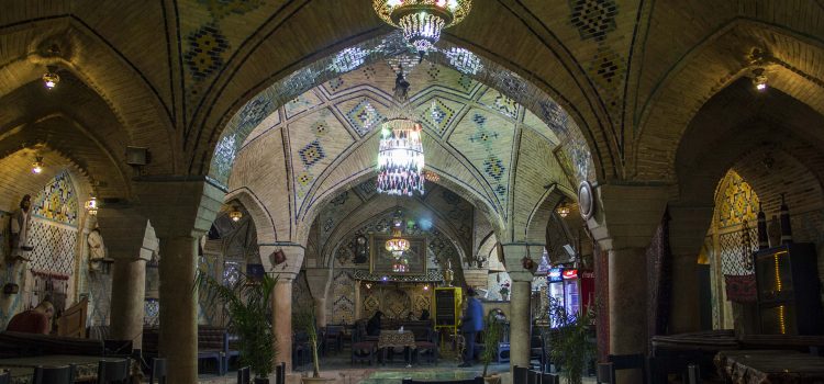
The complex covers an area of 11000 square meters and is centered on a large public square—ninety-nine meters by fifty-four meter—which is aligned with Vakil Bazaar running east-west to its south. The square is enveloped by bazaar arcades to the north, south and west and is flanked by the Ganjali Caravanserai to the east. The entrance to the Ganjali bathhouse is located along a section of Vakil Bazaar south of the square, known as Ganjali Khan Bazaar.

Ganjali Khan was one of the famous rulers during the reign of Shah Abbas of Safavid. As the ruler of Kerman province he constructed many monuments and buildings, displaying a modern architectural style of the time. Ganjali Khan complex is composed of a madrasa (school), a square, a caravansary, a hamam (public bath), a water reservoir, a mint house, a mosque and a bazaar. A number of inscriptions laid inside the complex indicate the exact date when these places have been built. The architect of the complex was Mohammad Soltani fromYazd.
The Ganjali Khan Bath in the complex is situated on the southern side of the rectangular complex. This is a unique work of architecture with beautiful tile works, paintings, stuccos, and arches. The entrance of this bath has been artistically painted with ornaments of the Safavid era. The most interesting feature of its architectural finish is that the sculptured stones of the ceiling coincides with that of the flooring.

An exquisite blend of art and architecture,this building has a staggered entrance which opens into six spacious apses. Upon entering the Bath, a dim, narrow, curving aisle leads visitor to an octagonal vestibule, itself linked to the cloakroom by a similar aisle. It has six separate changing rooms for the various social classes: the sayyeds, clergy, khans, wealthy merchants, and the common people. Currently in each one of these sections, two statues portray this scene. From the changing rooms one enters the bath proper, an area of 46 by 30 meters. Narrow passages lead to a row of halls, each of which had a specific use such as massages and hot and cold baths. The main bath comprises of a cold water pool with a ceiling similar to that of a tent supported by eight beautiful pillars.
The bath rendered service no later than 60 years ago. The ceiling of the bath was originally covered with fine marble that admitted light from the outside. Later marble was replaced by glass. Sunlight pours in from the roof overhead, creating superb light effects. Water from an underground qanat, which the Khan himself twice excavated, flowed out in the city square and fed the city cistern. Although the cistern was built in the time of Ganjali Khan, it is known by the name of his son Ali Mardan Khan, whose name is in the inscription. The cistern is 19.5 by 10 x 9 meters can hold some two million liters of water.
The Ganjali Khan Bath currently serves as an anthropology museum and attracts an increasing number of Iranian and foreign tourists. In the closet section and main yard of the bath there are many life-like statues which demonstrate how a bathhouse functioned, bringing back the memory of everyday scenes from its past.. These statues were designed at Tehran University’s faculty of fine arts in 1973 and then transferred to this museum. All garments and exhibited objects are period pieces: razors, phials for rose perfumes and long-stemmed pipes to be enjoyed after the bath.